End of June 2009.
3 months ago, I was still using my bike to bring/fetch my kids to/from school in my home street. Last weekend, I used this same bike to conquer the legendary Mont Ventoux, no less than 3 times (starting from Bédoin, Malaucène, and Sault, respectively). Imagine that ... !
Thursday, June 18, 2009. Packed my suitcase the day before. Had another large spaghetti (like the preceding days) before taking off at 10:00, to avoid the usual traffic jams. Stopped every 2 hours, arriving at 19:40 at the hotel in Carpentras, about 15 km from Bédoin. Unsure about what to wear during the different times of day on Saturday (while consecutively attempting all 3 ascents), I decided to take the temperature of the enemy, thereby (although driving my car in the dark) also getting a first impression of its size and shape. This resulted in 24 degrees Celcius at 22:15 in Bédoin; half an hour later in 15 degrees at the 'Observatoire' on the top of the mountain; and another half an hour later in 22 degrees at Malaucène. After that, straight back to the hotel to get some sleep (unfortunately having had to aim a big desk fan straight onto the bed, because of no available airco within the entire hotel).
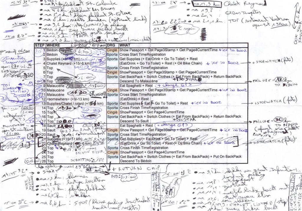
On Friday, Sporta registrations for the event (and handing over a backpack that would be transported to and stay on the top of the mountain) needed to be concluded before 19:00, so I had plenty of time to do a virtual tour of the entire Bédoin - Top - Malaucène - Top - Sault - Top - Bédoin trip by car on beforehand. I again took the temperature at different spots, this time at noon and in the afternoon. I also wrote down the most notable trip milestones (like e.g. the beginning of tough climbs), just to know what would still be ahead when actually cycling on Saturday. Also, I needed the opening hours of Chalet Reynard (at 6.2 km from the top where the Bédoin and Sault tracks join), of Chalet Liotard (at 5.9 km from the top on the Malaucène trajectory), and of restaurant Vendran at the very top of the Mont Ventoux itself. Combined with the intermediary Sporta drink/food supplies (one instance per track) being available only until 19:30, and armed with some local shops/restaurants opening hours at the 3 starting points (to timely obtain all necessary Cinglé stamps within one 24 hours window, see further below), I distilled the following timetable (based on a realistic/training average climbing speed of 7 km/h and 15+15 minutes rest per track) :

A couple of months earlier, I had extensively consulted the De Kale Berg website. I had also ordered and read the excellent 'De Kale Berg' bestseller book (in Dutch, which you can also find on that website), being full of good advice on all possible fronts, and containing some very hard testimonials. After having prepared another checklist about what to put in my backpack (to be transported to the top) and what to keep on my bike (like muscle reflex spray, etc.), I think I was very well (perhaps even overly) prepared to commence my journey, to say the least. But, as we will see, one should never underestimate the enemy ...
After having slept for about 6 hours during the night, I was extremely nervous on this Saturday morning. Was I not forgetting anything ? Did I train enough back home ? Was I simply being crazy wanting to try an out-of-category col 3 times in a row on one single day ? Anyway, I went to the start in Bédoin (already missing the optional 8:30 group departure), stuffing another 3 bananas into my stomach underway, just to be on the safe side after a very mediocre breakfast in the hotel. Having arrived there, I first quickly obtained a Cinglé stamp and some ice into my booze.
First disappointment : all backpacks that were handed over the day before had come back from the top of the mountain to all starting points (luckily mine to Bédoin), because of too much wind (i.e. the feared mistral) on top of the mountain. That immediately meant another couple of unnecessary kilograms on top of my own weight (about 89 kg), my extraordinary bike's weight (18 kg), my 2 liter Isostar North Face backpack, an extra 1/2 liter of water, plus my already packed wind jack, thermal suit, and just-in-case medicines. Luckily, the weather forecast was very ok compared to the day before : a maximum of 26 degrees Celcius instead of 33. When I finally crossed the start line, at 20 degrees Celcius (wearing only 1 layer of clothing with energy bars in the back pocket), the clock showed 10:30.
The first 6 km segment on this track has a lower gradient than the following unforgiving 9 km through the forest at 10%. However, after 1 km (still taking it easy), my heart was already pounding at 165 bpm. Slight panic ... Thinking I'd surely blow up myself when the real thing would come further on. Switching to first gear to conserve leg power. No effect. Trying to relax. Zen ...
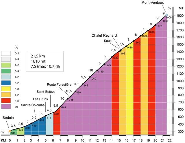
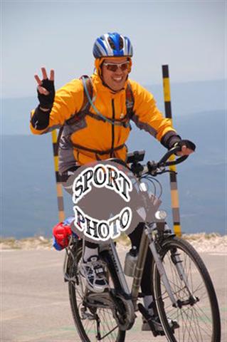
Since the drink/food supplies are supposed to be at 9 km (in fact, they were at 10.5 km), I'm watching my telemetry as every 100 meters are passing by. My heart rate is now 170-175 bpm (sometimes even 180 bpm), while maintaining a healthy cycling cadence of 80 rpm. Because I know that my lactate threshold lies around 175 bpm, I'm still positive that I'll be able to make it to this first stop. A lot of sweat later (after 1 hour and 15 minutes), I'm there. No problems with the legs, but applying some muscle reflex spray anyway. After a 25 minutes break, just to stay on the defensive side, I'm taking off again direction Chalet Reynard. Another 40 minutes later, I arrive at the chalet, still in good shape. After a 20 minutes break, having consumed a couple of Isostar energy bars, I decide to push through to the top. This takes me another 55 minutes, fighting the wind while I'm at it. At around 14:00, some photographer alongside the road takes a couple of pictures (me in the yellow wind jack). A couple of minutes later (having passed quite a number of people who had given up and were stepping beside their bike), I'm crossing the finish line, right according to plan (although of course delayed by 2 hours). I must say that the wind was tough, but still reasonable, between Chalet Reynard and the top. Only during the last right turn before the finish line, I had to briefly put my foot on the ground in order not to get blown off my bike. Some Sporta organizing people were actually helping lots of participants to get past this nasty last turn.
Hungry, so eating some tagliatelli at the Vendran restaurant (and obtaining my second Cinglé stamp of the day). Then, after having switched socks and first clothing layer, and having put on my second layer plus wind jack, a relaxing 20 km = 30 minutes descent to Malaucène, pumping the brakes to stay under 50 km/h most of the time.
Near the end of the Bédoin ascent, being proud to have made it without any notable problems, I was really wondering whether all those heroic Mont Ventoux stories in books were perhaps exaggerated. How I would change my mind about this during the next couple of hours ...
After obtaining my third Cinglé stamp and some bread at the local bakery, eating a couple of bananas and some orange parts, I decide to start the Malaucène track at about 16:45, happily catching up with my original plan. After about 7 km, the wind starts blowing really hard and I feel I am getting exhausted, only advancing at 5 km/h. Therefore, I stop a bit earlier than at my planned 8 km milestone (i.e. about halfway toward Chalet Liotard).
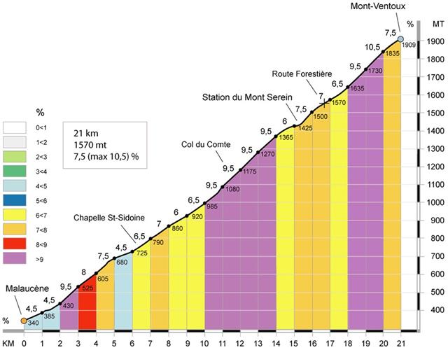
After 20 minutes, I feel slightly better, but I realize I will not be able to make in time (i.e. before 19:30) to the Sporta drink/food supplies at Chalet Liotard if the wind continues like this. Fortunately, that is of a minor concern, because during my earlier scouting I learned that the chalet would stay open until at least 20:30. Very unfortunately, this delay also implies that I need to seriously start considering to perform the Sault ascent on Sunday, which I'm not too happy about. Anyway, I continue the fight, but realize I am getting more exhausted and very cold because of the steep road and the damn wind, necessitating another stop at the 10.8 km mark. This time, I am getting depressed, for a moment even contemplating to just give up and return to the 25 degrees Celcius Malaucène start, and do an extra 13 km on normal terrain back to my car in Bédoin. Instead, I decide to get warmer and put on my thermal suit. When I park my bike, it immediately gets blown over by the wind, so I have to put it on the ground and see to it that the contents of my backpack stay with me. There's no shelter, so I need to change clothes right in this freezing wind. While performing this stunt, another participant is passing by and suddenly gets blown a couple of meters to the right, resulting in a lot of cursing. I sympathize, but decide to stay a bit longer to recuperate.
After half an hour, I again give it a further try, totally abandoning the give-up scenario, since it's only another 4 km to Chalet Liotard. The wind doesn't care about all my considerations, and I have to stop again at 12.5 km, totally crushed. I'm almost throwing up upon trying to have another energy bar, and the Isostar drink doesn't taste anymore either. I just keep sitting there for half an hour (trying not to turn my sweaty cold back to the wind too much) until I can pull myself together again. I simply stop thinking and just observe the telemetry, counting down toward Chalet Liotard. Finally, at 20:10, I arrive.
I immediately order a tagliatelli, put on dry clothes, and simply rest. At about 21:10, I feel ok again, so I head for the door to go and perform the last 5.9 km to the top. Coincidentally, some Sporta guy enters the chalet, informing me that I was more or less reported missing, because there's nobody at the top anymore. Apparently, Sporta canceled the entire event at 19:30, because of the wind blowing way too hard at the finish. He asks me wether I want to continue or go back, and I answer affirmatively up (explaining about my 24 hours Cinglé attempt, which is unrelated to Sporta). Luckily, he supports me and returns to the finish line by car, intending to manually register my arrival time when/if I get there. Since I feel quite alright again, I depart and push it a bit (at around 170 bpm heart rate), to not keep this guy waiting for too long. The wind is a lot better than before, but when I reach the top at the 'Observatoire' about 1 hour later, I almost get thrown off my bike and have to step a couple of meters. After an attempt to get on my bike again, I again loose my balance, so I step toward the last turn past the Observatoire. Here, the mistral is blowing so hard that I almost loose my bike. I can only keep my bike with one hand, so I have to literally lie down on the ground in order not to get blown off the mountain myself. After a short crawl, I can stand up again, and I move against higher ground toward the finish where the Sporta guy awaits me. He registers my 20:11 arrival time while I take shelter. Because the wind is too dangerous, we decide to put my bike in his minivan, and descend to about 3 km lower in the direction of Bédoin, where the wind is a bit calmer. From there on, I perform the remaining 18 km descent all alone in the freezing cold and dark, utilizing my brand new Petzl. I'm not risking to go over 40 km/h under these conditions, and arrive halfly frozen at my car.
Next problem : back in the hotel, getting all my stuff ready for the final Sault ascent on Sunday, I need to set my alarm clock on 5:45, so that I can leave the hotel at 6:30 and start at Sault between 7:00 and 7:30 to timely reach the top before 10:30 (to stay within the 24 hours Cinglé limit). Totally exhausted, I finally get into bed at 0:45, but I'm still awake at 1:30, partly because of the room heat + desk fan combination, and partly because of this tough day's emotions continually replaying in my head.
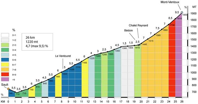
The Sault ascent is generally considered to be quite a bit easier than the Bédoin and Malaucène ones, although being about 5 km longer. However, that Sunday, sleep deprivation and recuperation failure were about to prove otherwise ...
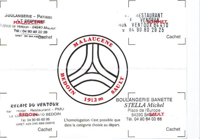
Sunday morning. Everyone in the hotel is still asleep. I manage to leave (without breakfast) at about 6:45. Once in Sault, directly to the local bakery. After obtaining my last Cinglé stamp, I buy and try a couple of small fruit pies, suggested by the baker's wife. I hardly manage to get them down my throat, feeling sick because of 4 hours of sleep after my heavy labor the day before. I also try a small 'baguette' (french bread), but I just keep chewing on it. Luckily, the first part of the Sault track goes down instead of up, and I'm packed lighter because today there's no need for the extra backpack.
After the first couple of meters uphill (at only 5% gradient), I sense I have no power at all in my legs. To make the feast complete, the wind starts blowing again. At that moment, I'm realizing I will never be able to make it to the top before 10:30, so I decide to go very slowly and not give up, even if it would take me all day to complete this final trip.
After 5.7 km (and only 130-140 bpm heart rate), I just must take a stop, whether I want to or not. There's really no point in keeping pushing ahead on low battery, yawning all the time. 10 minutes later, I'm battling the wind again. I'm doing some arithmetic to have an idea on where to stop next, but after 2 km, I'm cracking again. Luckily, there's some shelter with some benches in a small half-open barn, so I switch my first and second clothing layers (because I forgot to take spare ones with me). I'm not putting on my thermal suit, yet, because I want that one to stay dry for the final chalet-to-top ascent. Also, I put the small towel hanging out from my helmet to protect my neck into my cycling trousers to keep my lower back dry and warm. I'm putting on my wind jack's cape and reattach my helmet on top of it. I put my head down on one of the benches and close my eyes for a couple of minutes. Then, I'm off again for another couple of kilometers.I am forcing myself to drink now and I'm only eating very small energy bar parts. Bingo again somewhere around 10 km from the start. I just sit down for a while, and then take off again, because I am getting too cold. The wind keeps harassing me, and there's nothing I can do about that. At that point (not bothering to take notes anymore), I'm really getting into problems. I stop at some bench behind a tree alongside the road (where the road takes a left turn), I sit down, and I doze for about 10 minutes. Then, I see 2 ladies approaching (seemingly younger than me), also stopping in the turn of the road to take a drink. I get up and start chatting to them, explaining my calvary thus far. Apparently, this is their first ascent, so they are still fresh (although they also had to fight the wind). This all really helps my motivation, and I'm leaving right after them, slowly loosing sight of them. At that point, the Sault track becomes a lot easier, diminishing to about 3% gradient for a couple of kilometers, so I'm having a better time than before. However, a small 4.5 gradient segment forces me to step down again, but I don't mind anymore, since I know it's only another 3 km to Chalet Reynard. Almost there ...
After 5 minutes, I push the wind aside until I reach the chalet (at approximately 10:45). Both ladies are finishing their drinks, and I admit to them I had to take one last break after our previous encounter. There, the Dutch speaking lady tells me she has recovered from cancer, and she will take it easy to go to the top. We say goodbye, and I'm having a miracle tagliatelli, feeling my power slowly returning. After a while, since I'm still dizzy from my lack of sleep, I inform the boss I'm going to try to take a nap for about half an hour, head down on the table. I'm not actually sleeping, but it helps. Another half an hour of yawning later, I freshen up, put on my thermal suit, and on my way out encounter both ladies again. The French speaking lady made it to the top in 45 minutes, and the Dutch one took 3 stops. I'm telling myself and them that I will push in one move to the top, to finally get rid of this mountain.
I'm off at 12:41 and reach the top a good 56 minutes later, at 13:37. Another fotographer was kind enough to take a couple of pictures about half a kilometer before the finish. Every inch of this last ride, I was wondering whether to really keep fighting the wind all the time, or take it easy and step down a couple of times. In fact, I just kept thinking this same thought and simply refused to step down (going slower at 75 rpm cadence and 155-160 bpm heart rate to preserve energy), making myself proud.
At the top, I bought a couple of souvenirs (in the only available souvenir shop), and after a well deserved beer in restaurant Vendran, at around 14:15, I hurried down in my 4 layers of clothing to Sault (taking about 45 minutes). In Sault, the temperature was over 25 degrees Celcius, so I was like returning from a North Pole expedition into a desert.

The Sporta farewell party at Bédoin was only from 13:30 to 18:00, on the same day. However, once back in the hotel, I couldn't resist lying down on the bed for some time, before showering and going over there. I arrived at 17:30, still hungry after the last push to the top, so I quickly had some French fries (or should I say 'Belgian fries' ?) and a glass of white wine. After some conversations with people from the hotel, I joined Marc De Jonghe (who is an ex-collegue of mine and fellow chess player from way back, and with whom I kept sms-ing during the entire event) and his wife Rita in Vaison La Romaine to have some decent food/drinks and replay our heroic efforts of the last couple of days. It just happenend that Marc performed the tougher Bédoin ascent after the Malaucène one, heavily struggling with the mistral wind as well. Hats off !
After a long sleep, I apparently was the only one left in the hotel. I took off at 11:00, reaching home at 21:00 (because my GPS refused to follow a 45 minutes shorter route through Luxembourg). At least during the last 750 km, I was plagued by annoying middle/lower back and butt cramps, so I repeatedly had to apply muscle relax spray to get home in 1 piece.
Well, in retrospect I couldn't have prepared any better, I think (except for a longer training period, but I only came to the idea of actually participating about 4 months ago). On D-day itself, I should definitely have started earlier to keep more reserves for unforeseen weather conditions, physical fatigue, etc. Of course, that is easier said than done after sleeping in an uncomfortable bed inside a too warm hotel room. Also, this time I literally did everything by myself to keep a 100% focus, 100% of the time (not really knowing what to expect). Next time, I would surely go for a more social (group) approach, which presumably would be more fun and more supportive.
Obviously, the same old mantra applies over and over again : never give up ! That was quite alright for me, since I'm used to showing some character, anyway. It's amazing what one can accomplish, when simply making it a priority and really putting one's mind (and in this case body) to it. Yes : mind over matter ...
Also : be self-confident ! Lots of people are giving good advice with the best intentions (from stripping your bike over urging you to train 5 times a week, to measuring your weight loss to calculate your necessary food/drink intake, etc.). Just do what you find comfortable and try to find your own balance, but be prepared to work hard for it and even suffer during trainings.
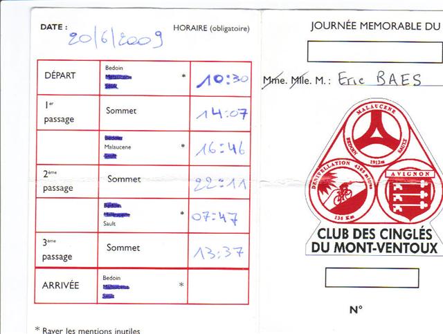
As a final note, subscribing for the Cinglé attempt was an extra motivation that kept me going. I know I actually failed this qualification, since the whole trip took me 28 hours instead of 24 (and I doubt extreme wheater conditions being a valid excuse to get some sleep in between). Anyway, I don't really care. Perhaps it's better not be a nutcase club member after all ... I do consider my 3 successive ascents to be a very big personal victory !
This experience was very very hard and I had to go very very deep. Hence : never again ... ?
Yesterday evening (on 2009-06-16), I cycled the M-route again, this time in complete outfit : including a 2 liter hydration backpack, cloth bottle cooler (for my energy bars in my racing suit back pocket), decent sunglasses, etc. Again, normal telemetry for an easy circuit with only 1 real hill, as expected : 135 bpm average heart rate (and 85 rpm cadence) in 2 hours 15 minutes at rougly 20 km/h for 45 km. This concludes my 3 months training sessions.
Tomorrow, I'll be heading off to 'la douce France'. Wish me luck !
I haven't jogged anymore since half May. Therefore, I haven't experienced running my usual 8 km at 165+ bpm heart rate. I decided to completely focus on cycling during this last month of training. Well, plans are worthless anyway; it's the planning that counts ...
Today (Sunday, 2009-06-14), I managed to cycle the M-route around Geraardsbergen (yes, even without any detectable signposts during the first couple of kilometers). I didn't bother creating a GPS loadable gpx file via my MapSoure software, but simply held the printed one page map folded in my left hand while cycling. About 10 km before the finish, I suddenly noticed my map was gone. Unfortunately, I had needed it before and apparently I still needed it further on because of an ambiguous signpost (indicating straight ahead when the road split into two parallel straight aheads). After the trip, I learned that I performed an additional 12 km of backtracking on top of the planned 45 km. I admit I did not consult my map at every single crossing. Instead, I simply assumed straight ahead in absence of signposts (which is a reasonable default). Big mistake ... ! After a particular miss, and significant backtracking, I even removed some guilty small branches from a tree that had covered up the signpost.
Anyway, I spent 3 hours on my bike at an average heart rate of 130 bpm (maximum = 170 bpm, but I can't remember where that came from). Average cadence : 85 rpm, as usual. I was a bit disappointed that the infamous 'Wall' was not hard to surpass, perhaps because it already came very early in the trip. In fact, I only started this multi-segment hill from where I parked my car (near the Markt/Vesten intersection). I performed the Brugstraat/Markt segment at the end of the entire trip, but that also did not pose any problems (since not being very lengthy).
This week, on Wednesday (2009-06-10) and on Friday (2009-06-12), I didn't have time to do the usual 2 hours of car driving on top of a (minimum) 3 hours training. Thus, I resorted to my home trainer (each time after a home trainer warm-up and fitness session, that is). I sat twice one hour, and one hour, respectively, on the machine, cycling 35+35 and another 35 km at around 140 bpm heart rate (always at 100 rpm cadence), soaking wet after each finish. Also, my legs were slightly hurting, so the effort must have been wortwhile.
On Monday, 2009-06-08, I went back to the Denderoordstraat in Geraardsbergen. I performed 30 (= 15 + eating break + 15) iterations, as suggested before. I decided to take it easy, always switching to first gear soon enough to spare the legs. It took me around 1 hour 40 minutes for each half (actually, a couple of minutes less and more, respectively). My average cadence was 80 rpm in both cases, and I was often at 75 rpm (and 6 instead of 7 km/h). My average heart rate stayed below 170 bpm at all times, and about half the time I reached 'the top' below 160 bpm (a couple of times even at 155 bpm). Nevertheless, I was happy when it was over, because at the end it became a bit boring.
Today (Friday, 2009-06-05), I decided to repeatedly perform the Denderoordstraat ascent at Geraardsbergen : each time 700 meters at 10% inclination (see also '11. Around the wall' below). It took me exactly 1 hour to do this 10 times in next to smallest gear, at 170-175 bpm maximum heart rate and 75-80 cadence. After a small break, I repeated the exercise 5 times in smallest gear, all at 165-170 bpm maximum heart rate and 80-85 cadence. After each descent, my heart rate consistently returned to 110-120 bpm. Next cycling session, I should perhaps go back there and perform 30 iterations in total, matching 1 Mont Ventoux climb (although I would be recuperating during all 30 descents).
Yesterday (on 2009-06-02), it took me about the same time (i.e. 1 hour 48 minutes) to perform all 3 segments of my training circuit, although now at 140 bpm average heart rate (maximum : 175 bpm) and 85 rpm average cadence. The temperature was between 20 and 25 degrees C, which was really nice. After the break, I performed segment 1 backwards in 47 minutes (so not pushing too hard). Average heart rate : 135 bpm (at all times staying below 170 bpm). Average cadence : slightly above 80.
In summary, my training circuit consistently leads me to an average heart rate range of 130-150 and maximum heart rate range of 160-175 (depending on tourist/push mode), and an average cadence of 80-85.
3 more weeks to go ...
Today (Saturday, 2009-05-30), the weather was very nice : well above 25 degrees C again. Nevertheless, I decided to really push it (yes, on my Maarkedal training circuit), resulting in 40, 20, and 48 minutes for the 3 segments, respectively. This means I improved each segment by 2 minutes. Obviously, this did not come for free : my average heart rate was 150 bpm, at an average cadence of 85 rpm.
After resting and eating, I wanted to check the impact of least effort cycling (i.e. almost like a tourist, switching to smaller gears to spare the legs). To throw in some variation, I performed segments 3 and 2 in the opposite direction, leading to 55 and 25 minutes, respectively. My average heart rate was only 130 bpm, while my maximum was just slightly over 160 bpm (instead of the usual 170+), all at an average cadence of 80 rpm. As opposed to my previous attempts, this one was not tiring at all, so I'm wondering what would be the best approach : take it easy, or go 15% faster by burning oil. Unfortunately, on the Mont Ventoux, the easier way (I think 'easy' simply does not apply here) would amount to an extra 30 minutes on top of the planned 3 hours per climb. Considering my usual performance degradation after approximately 3 hours, as experienced through the longer Sporta trips, I'm not sure which approach would represent the lesser of both evils ...
Last Wednesday (on 2009-05-27), I went back to Maarkedal. The temperature was around 12 degrees C, and the first half hour it was drizzling, which I didn't mind at all. This time, I decided to do the entire 32 km trip in one shot, verifying my finalized step-by-step directions (which turned out ok) on the fly. Segment 1 (12 km, Schorisse church - Schorisse church) took me 42 minutes, segment 2 (6 km, Schorisse church - Maarke-Kerkem church) 22 minutes, and segment 3 (14 km, Maarke-Kerkem church - Schorisse church) 50 minutes, i.e. 1 hour 54 minutes total. Average heart rate : 140 bpm (maximum still under 175), and average cadence between 80 and 85 rpm. After that (and an eating stop), I performed segment 1 again : same data, except that it took me slightly longer : 44 minutes.
Sunday morning (on 2009-05-24) in Borzée, near Bastogne, I started another Sporta training trip of 100 km. In the early afternoon, the weather became really hot (> 25 degrees C), without much shadow. Therefore, I decided to take a shortcut at the 100/175 km split. (I imagine nobody dared take the 175 km route, except perhaps when utilizing some cooling device). Result : I cycled only 75 km, but that was tough enough : my average heart rate was 150 bpm ! Other measurements were as expected : an average cadence of 85 rpm and average speed of 15 km/h, so 5 hours on the bike. I briefly stopped after 1.5 hours and a bit longer at the supplies after 3 hours.
Yesterday (on 2009-05-22), I went back to verify (while performing) my training route. I took me 2.5 hours (but in fact only 2 hours of actual cycling time, since I was stopping at each couple of turns to take notes/corrections, which I integrated into the turn-by-turn route description below). My maximum heart rate was 175 bpm again, at an average cadence of 85.
The entire training route is 32 km long. Perhaps an even better strategy would be to first repeat the initial church-to-same-church closed loop a couple of times, since these 12 km contain 4 out of all 8 hills. Each iteration easily takes less than 1 hour to complete.
Just changed my jogging heart rate zone to 165-170. I have no clue how else I should try to adapt to long continuous high frequency heart pounding (which hopefully is comparable to the real thing awaiting me on the Mont Ventoux). After all, that's what the doctor ordered ...
Last Thursday (on 2009-05-14), I cycled 45 km in and around Maarkedal (near Oudenaarde). This reasonably prepared trip (including 10 hills) took me 3 hours at an average cadence of 80 rpm, with a maximum heart rate of 175 bpm. Unfortunately, 15 minutes before reaching my car, Murphy's Law kicked in : it started raining cats and dogs. Not having brought any towels with me, I remained soaking wet the whole trip back home.
That was my first attempt at synthesizing my own training circuit.
Last Monday (on 2009-05-18), I went back there with a more detailed prepared map. I first tried almost the entire trip by car, went back and forth, and eventually found a suitable sequence of hills and non-hill segments. I then cycled this plan, but still missed a couple of streets. As a result, I did 40 km in 2.5 hours (again with a 175 bpm maximum heart rate and a slightly higher cadence than a couple of days before).
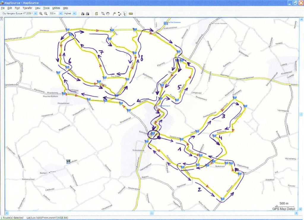
The finalized trip (which you can see on the map further below) is under 35 km. It contains 8 hills, their most important properties being listed in the following table :
| Id | Name | Length(m) | Climb(m) | AvgGradient(%) | MaxGradient(%) |
|---|---|---|---|---|---|
| 1 | Foreest | 685 | 51 | 8 | 12 |
| 2 | Steenbeekberg | 725 | 55 | 7 | 14 |
| 3 | Steenberg | 821 | 60 | 7 | 12 |
| 4 | Ganzenberg | 1200 | 70 | 6 | 17 |
| 5 | Den Daele | ? | ? | ? | ? |
| 6 | Kapelleberg | 735 | 52 | 7 | 13 |
| 7 | Boigneberg | 1050 | 53 | 5 | 12 |
| 8 | Varent | 808 | 59 | 6 | 13 |
Let's provide all directions, so that you can try out this route for yourself :
Yesterday (Sunday, 2009-05-10), Sporta organized a 100/140 km choice trip, starting at Tervuren. I couldn't join (because of my chess teaching activities), so I decided to do (part of) the trip in the afternoon. I cycled to the 50 km point where the road split into both choices (in Beauvechain). From there, I went straight back (by GPS) to the starting point, which resulted in another 22 km. All of this took me 5 hours, including a couple of long stops. The most interesting climb no doubt was the Chaussée d'Ottenbourg, if I remember correctly. Anyway, my heart rate never went above 170 bpm. Since I didn't push much, my average heart rate was 132 bpm (and average cadence 83 rpm).
Apparently, I need to forecast an average speed of 15 km/h when the route involves some long climbs. Otherwise, on relatively flat surface, my average speed is 20+ km/h. Considering my weight and 'tank' vehicle, this is quite alright.
Yesterday (Thursday, 2009-05-07), I planned to do the M-route, which is only 45 km long, but contains the dreaded Wall of Geraardsbergen. Unfortunately, already after 50 meters, I could not find the next M-route signpost, due to roadworks, so I quickly decided to just follow my nose. Apparently, my nose led me around the Wall instead of over it, so I just continued more or less randomly. I started by cycling a reasonably long descent and at the end just turned around and climbed all the way back. After that, I luckily spotted the Denderoordstraat which seemed to have a good inclination (the road sign at the other end mentioned 10%). After my first ascent, I learned from my GPS that its length was 700 meters, so I decided to simply stay there and do some benchmarking by repeatedly going up and down (about 10 times). I gathered the following data : heart rate 165-175 bpm, cadence 80-85 rpm, and resulting speed 6-7 km/h (all in smallest gear). Apart from my heart rate, which I would prefer not to cross the 170 limit (my maximum is around 190), I'm ok with this baseline. The only difference with the Mont Ventoux is that the latter is about 30 times longer, without in-between descents ...
Yesterday, I also purchased a Garmin route planner ('MapSource'), so that I can now start creating my own custom trips. In fact, I would like to construct a 3 hours route containing as much (different / lower than 15%) hills as possible.
Last Sunday (on 2009-05-03), I wanted to do some real climbing, so I decided to try the toughest Tour of Flanders loop (i.e. the orange one). This loop is 72 km long, and it contains no less than 9 hills. I misjudged this one quite a bit, because I started cycling at 17:00 and only concluded my trip at 22:30. Unfortunately, I also learned the hard way that I simply am not (and probably never will be) physically able to climb cobblestone slopes that are above 15%. I came to a full stop about halfway the Paterberg, after one third of the Koppenberg, and relatively early on the Taaienberg (if I'm not mistaken), respectively. Luckily, the Mont Ventoux doesn't require this kind of power, but I have no doubt the endurance aspect will be crushing.
Back home, during the early morning around 6:00, I suffered terrible cramps due to my earlier massive intake of sugar coated gingerbread (which I always combined with bananas up till then). Therefore, I will be trying out Isostar energy bars from now on (keeping the bananas), since I don't like the raisins in some of the competing products. I'm not sure yet about the frequency and amount of food I need to eat while cycling, so that's one of the things I'll no doubt learn during the coming weeks.
Countdown : 6 weeks to go ...
After having been subjected to a lactate threshold test, I have changed my jogging heart rate zone from 147-153 bpm to 160-165 bpm. As a consequence, I'm now running at 10.5 km/h instead of 9 km/h.
Yesterday (on Sunday, 2009-04-19), I again joined an organized Sporta trip of 80 km, this time around (and over) the Kemmelberg. It only takes a couple of 100 meters to cycle over the mountain itself, but the cobblestones on this 11% (and at the end 20%) steep road make the ascent a bit shaky. The entire trip definitely was a lot harder than the Cauberg trip 2 weeks ago. More than once, I could not keep up with the race bikes on long climbs, so afterwards I closed the gap at 183 bpm heart rate. This probably partly explains why, on this more than 4 hours trip, my legs almost gave up on me when there was about 1 hour of cycling left. Anyway, my average heart rate of 145 bpm (with 85 rpm average cadence) still suggests I'm doing a reasonable job.
Apparently, group cycling is quite dangerous. I witnessed one guy braking wrongly at less than a meter before me on my left, and the next moment his bike flew over his head (which I luckily could evade). He hit the ground very hard, and he almost hit it again when trying to stand up, so at that moment his trip was over. Also, later on, another guy hit the ground (but I couldn't see the details through the crowd before me). Fortunately, that one was able to continue his journey. Like always, some people get flat tires. In principle, this should not happen to me, since I'm driving a tank amongst lightweights.
After driving my oldest son to a vacation camp near Bruges, on the way back I cycled exactly the same trip as 3 weeks ago : Ghent-Lippelo. This time, I only stopped once, and I was a bit faster, with a better average heart rate of 145 bpm (keeping the same 85-90 rpm cadence). Afterwards, I was less tired than the first time, so this must be a good sign ...
Yesterday (on Sunday, 2009-04-05), I joined an organized Sporta trip of 80 km around (and over) the Cauberg. Its 1.5 km ascent at 12% steepness unfortunately resulted in a 183 bpm heart rate peak, so there's still some improvement work to be done in this area. Nevertheless, I finished the entire trip (with my trekking bike amongst race bikes) in 4 hours, counting half an hour for both short (right after the Cauberg) and longer (after 53 km) combined eating stops. My overall average heart rate was 145 bpm, with average 85 rpm cadence, so no problems there.
This event was the first time I attained 50 km/h on a bike. My GPS actually asked me to switch from bike to car mode, which I obviously declined.
Last Sunday (on 2009-03-29), I cycled 45 km in the neighbourhood (home to home). Again, it took me a bit under 2.5 hours (with one small stop) at 85 rpm and halfly frozen toes at the end. Everything happened at a lower average heart rate (135 bpm), though, since the road was relatively flat.
Last Saturday (on 2009-03-21), we had a family reunion because of my grand-aunt's 106th (!) anniversary. Halfway on the way back, near Ghent, I decided to jump out of the car and continue by bike. I pedalled a modest 50 km at an average heart rate of 150 bpm (heart beats per minute) and an average cadence of 90 rpm (revolutions per minute), taking a bit under 2.5 hours to complete (including 2 small eating stops). Almost home, I encountered a drunk cyclist, whom I decided to abandon after his couple of futile attempts to keep up with me, since my toes were halfly frozen during the last hour of the trip.
I increased my weekly Tuesday evening jogging session from 8 km to 16 km, while keeping the Saturday 8 km session. I'm not switching my jogging sessions into biking sessions, because I suspect these jogging sessions are a lot more efficient when it comes to aerobic training.
I'm planning to do bike trips each Sunday, and perhaps do some endurance hometrainer sessions on Thursday evenings as well. In combination with my muscle strength building fitness sessions, this really should be enough. If not, well ... too bad. I'll just suffer a bit more on D-Day. I'm not training to break any world records, anyway.
The first of several group trainings by Sporta was held on 2009-03-15 (on the Zolder race track). There, I got a first impression of my general endurance cycling condition. Also, I got a feel for suitable heart rate, cadence, slope/gear switching, and resulting speed combinations.
3 more training months to go ...
I will no doubt be sweating like a horse (and hopefully it will not get much worse than that) on 2009-06-20, which is the day when I will be attempting to reach the top of the Mont Ventoux, together with 1999 other participants through organizer Sporta.
There are 3 different roads to the top :
The main constraints are that Sporta supports the cycling effort during a 24 hours window (from Sat 2009-06-20 7:30 to Sun 2009-06-21 7:30), and that I will prefer not to cycle in the middle of the night.
Plan A is to perform all 3 ascents in the above order (i.e. hardest first). Plan B is to leave out Sault, but I consider the probability of this actually happening relatively low (unless this would force me to cycle during the night). Plan C is to call it a day after Bédoin, leaving out both Malaucène and Sault. Therefore, I will estimate and schedule maximum recuperation periods in the hopes of accomplishing Plan A. In case of successful execution, I would become a member of the legendary Club des Cinglés du Mont-Ventoux, i.e. the nutcases of the Ventoux ... Nevertheless, I strongly suspect that the execution of any plan will take a lot more than just my recent clean bill of health !
My cycle gear (i.e. Oxford Discovery trekking bike with Shimano Deore CS-HG50-9132 44/32/22 11-12-14-16-18-21-24-28-32, Polar CS300 heart rate monitor with speed/cadence sensors, Garmin nüvi 550 GPS, and cycle clothing) is all there, so only the training remains. Although not optimal, I decided to stick to my trekking bike (weight = 17.8 kg) instead of switching to a significantly lighter racing bike. I'll probably strip my bike right before the big event for maximum efficiency.